After a leisurely morning beginning with the $5.99 breakfast special at Sandy's (opt for the side of hash brown casserole; it's damned tasty) and a drive along Turkey Creek near Johnny Ringo's death site, we took Courtland Road back as we neared home. We diverted north onto the Pierce Road and stopped by some lovely stone ruins of what had once been a grand old building. Just west of it is the east flank of Turquoise Ridge, not far from the ghost towns of Courtland or, nearer to home and to the south, Gleeson.
These are the mountains I look out upon as I sit here at the computer. I see the south face of them, and the traces and slag from the old copper mines at Gleeson. Turquoise Mountain, though, is (shockingly enough) more known for its turquoise mining.
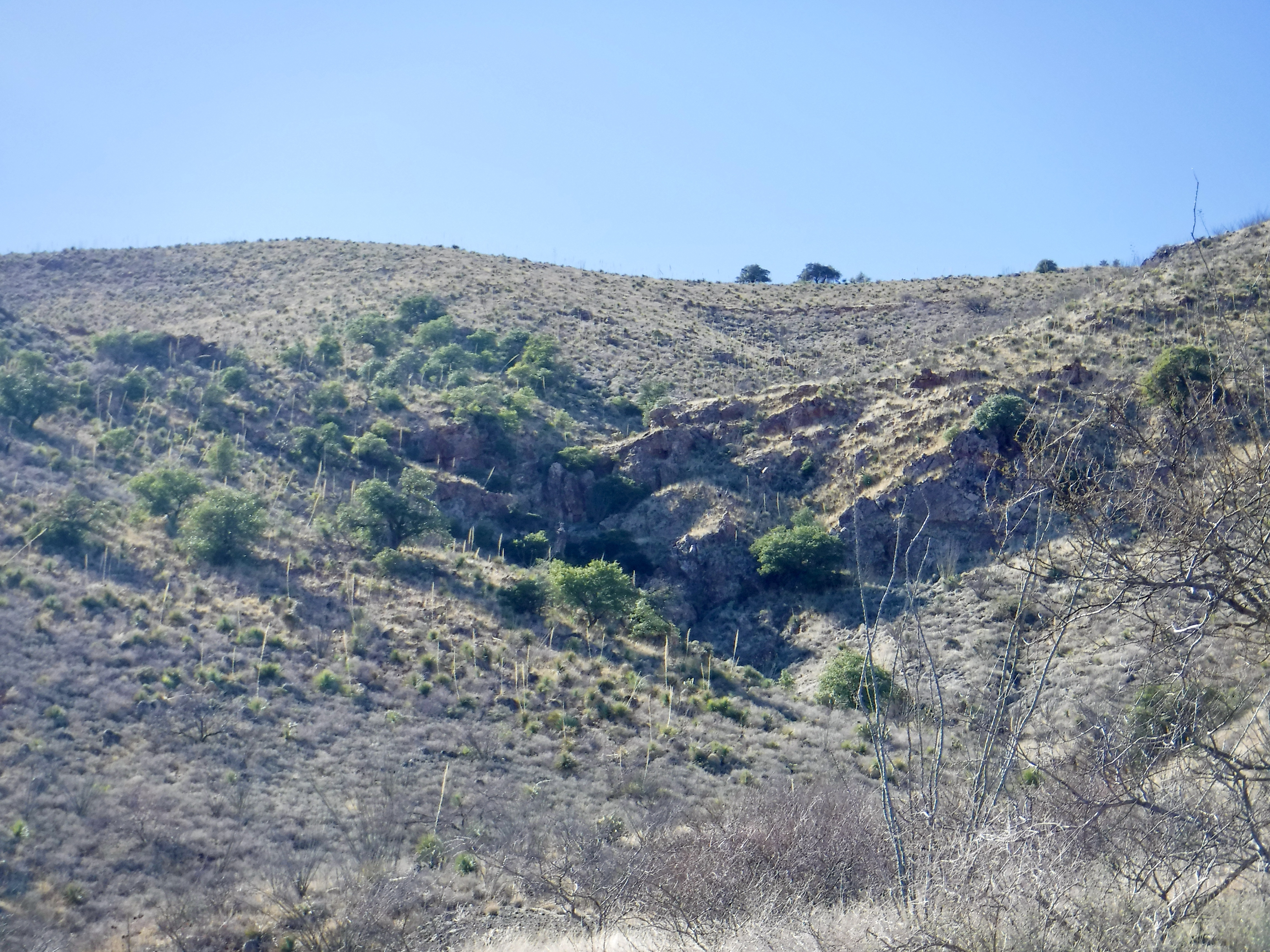
Today I wanted to see how close I could get to a specific gorge in the mountains, just below the ridge (see the dark "v" almost dead center in the photo above, taken from the ruins). Having not much time to hike back and still get home to give my special pup his meds on time, I figured I'd get as close as I could and then return with more time, a day pack with a sandwich, and my GPS to mark the site.
 |
| My other half, maintaining a comfortable distance as we hiked "together." |
Near here, along what was once the stage route that conveyed travelers to Tombstone starting in 1890, was the settlement of Turquois (as they then spelled it) and its multiple saloons, hotels, eating places, and store. There is no "first jail" where one can visit ruins; the "jail" was, in the 1890s, a live-oak tree to which offenders would be shackled by the ankle, as many as three transgressors at a time. Miners produced silver ore from the area (the Turquois Mining District) and freighted it to mills at Soldier's Hole in the valley below and to the east. The glory days didn't last long: In 1894 the demonetization of silver closed the enterprises. Miners abandoned the camp. Just two remained behind to dig for the semi-precious turquoise prevalent in the area that had long been mined by native people. Those two, Silas Bryant and N. C. Rascal, eventually deeded most of their claims to a New Yorker, G. Armeny. Armeny had the enviable fortune of contracting with Tiffany & Co. to provide the turquoise they sold. Despite turquoise selling for less per ounce than gold, Armeny made a greater profit than those digging the precious metal: he sent shipments of the blue-green rocks to New York for up to $500 a pound. Under various owners, the hills produced a great deal of turquoise up through 1936 when the claims, largely exhausted, were sold to Indian traders in New Mexico for jewelry crafting. (Source: The Dragoon Mountains, by Lynn Bailey.)
 |
| Some pretty rocks still remain in the Dragoons |
But back to the hike. We poked around some mining slag heaps and what appeared to be long-abandoned sites where ore was washed, then headed cross-country up the hillside to the small gorge that incited my curiosity. This time of year, there's not much greenery, but there - in the v of the mountainside - are green trees, what appears to be a small cave, and a field of ocotillo on the slopes. Often, ocotillo-covered slopes are a "tell" of underground caverns. The trees make me think there's a spring there.
 |
| Ruins near the slag heap. Note the horizontal pipe extending from the right side. |
There is a mining road, parts of which have long since seen any use, proceeding up to Turquoise Ridge, but the switchbacks built in for the safety of hauling ore make it more direct to just forge through the nasty-ass mesquite and up and down a few steep ravines. The terrain is rough and the loose rocks made my bad ankle turn on a few occasions, but with the assistance of a sotol shaft as a makeshift walking stick, I survived.
 |
| The intended destination. I got this close! |
We got as close to the little gorge in the hillside as possible before I decided to head back. So close! Within reach, but not today. Not the ocotillo in the lower right foreground and the vertical sotol shafts scattered across the slope in front of the gorge.
And so we turned back into the mesquite and the loose rock and made our way to the Jeep by the ruins.
 |
| The hike back on a stretch of old mining road. Note the two structures in the distance: That's where we parked. The Swisshelm Mountains are in the background, with the snow-covered Chiricahuas at left. |
The ocotillo faded away as we hiked, as did the sotol, leaving red rock, grass, and that blasted nasty-ass thorny mesquite. Plenty of lovely purple-hued antique glass dots various sites along the hike, along with rusted fragments of cans and plenty of cow chips from the herds that still roam the ranches here.
 |
| The path turned the prettiest color of rust for part of the hike. The Chiricahuas are at background right. |
 |
| We knew we were close to the Jeep when we hit this fork in the road. |
These mountains - the Dragoons - are filled with fabulous ruins, be they of stone-built buildings or concrete mining structures. I have to laugh reading Yelp reviews of the ghost towns here; a lot of readers are distinctly unimpressed because the ghost towns are "nothing but ruins." Some even put "ghost towns" in scare quotes to drive home the point they doubt that such remnants of the past are, in fact, ghost towns. Dear Reader, please note that a ghost town is, de facto, ruins and remnants and tattered, wind-eaten walls. You will not find cute boutiques here with T-shirts and scorpion-filled resin keychains. You're only 15 miles from Tombstone, though, so have at it. Here, you'll be able to visit the wonderful "living" ghost town at Pierce, the many ruins along the Ghost Town Trail (including at Gleeson, a mile from my home), and a shop at the privately-owned town of Turquoise, where you can even buy some turquoise. There's plenty to look at if you get out of your car and walk around those crumbling stone walls along the way.
 |
| Yours truly, old dog-eared ruins among the ruins. |
If you go: I'd call this a moderate hike; short, but with plenty of slope, rough terrain, and the nasty-ass mesquite. During warmer months you'll need water and to be very aware of the rattlesnakes. There are open mines, shafts, and pits throughout these mountains, so watch where your feet will fall at every step. The ravines are steep and slippery. There's often no one around, so be aware and be self-sufficient. No bathrooms. No trail guide. No signs. The way life ought to be. And if you pack it in, pack it out.
For further reading: I love this book by Lynn Bailey that I sourced above. If you buy it through this affiliate link, I thank you for your purchase as I may receive a commission. The Dragoon Mountains
Copyright (c) 2024 by Marcy J. Miller * All rights reserved * No part of this content may be reproduced without the express written or electronic permission of the author * Links, however, may be freely shared and are appreciated * Thank you for linking, liking, forwarding, citing, or otherwise helping grow my audience * Most of all, thank you for stopping by and taking a moment to appreciate this amazing state of Arizona.