|
Indian Mountain, New River
(c) 2015 MJ Miller
|
On the north side of New River Road as it snakes west toward I-17 a distinctive, small mesa overlooks historic Wrangler's Roost and Larkin Arena. The small peak, like so many of the area's formations, has been snubbed by maps. Known locally as Indian Mesa, it was well used by the Hohokam.
A quick climb from the senior center parking lot, the trail to the summit is short but slippery as you near the top, with plenty of loose rock to challenge your ankles. Don't try it on horseback, although excellent riding trails approach the base from all directions. The summit is surprisingly flat and level; it's no wonder indigenous people established dwellings here.
 |
Ruins of Hohokam Dwellings
(c) 2015 MJ Miller |
Ruins are abundant here. The Hohokam were temporary residents who farmed the lower valley but came to the New River area to hunt the more abundant wildlife. At the time, bighorn sheep ranged throughout the foothills and mountains; like the Hohokam, they are long gone. Many area petroglyphs depict the bighorn, doubtless popular game for the native people.
 |
Remnants of Past Inhabitants
(c) 2015 MJ Miller |
Visit enough ancient ruins and seemingly random scattered rocks quickly take shape into the ruins of dry-stone walls. Indian Mountain had numerous rooms atop the peak, with identifiable rooms on the southern base as well. If the summit once had the typical pot sherds in abundance, they've long since been picked clean; however, samples remain behind on one of the areas near the bottom. The sherds are sample of the Wingfield Plain variety from unadorned reddish or tan clay pots and ollas.
 |
Sample of Unique Rock Variety atop Indian Mountain
(c) 2015 MJ Miller |
If petroglyphs mark parts of Indian Mountain, I couldn't find them. I suspect the unusual rock comprising the mountain made etching too challenging; unlike the typical volcanic stone in the area, Indian Mountain has a harder, slicker prevalent rock. No geologist, I couldn't identify the stone; if you recognize it, let me know and I'll confirm and update this entry.
 |
Pepsi Cap Mountain
(c) 2015 MJ Miller |
Surrounding views from Indian Mountain are stunning. Pepsi Cap Mountain, also offering ruins, was once called Table Top Mesa until homesteader Rowena Essary named it Pepsi Cap for its cap-like top. Table Top Mesa is near Table Mesa, shown below. Since mesa means "table" in Spanish, it is of course redundant to have "table table" or "table top table" as a name - but descriptive, nonetheless.
 |
Table Mesa as Seen from Indian Mountain
(c) 2015 MJ Miller |
Looking south, the views of Apache Peak, Pyramid Peak and Daisy Mountain are nearly as gorgeous as the peaks to the north. Pyramid Peak is often erroneously called "Circle Mountain" because Circle Mountain Road arcs around it.
 |
Gavilan Peak
(c) 2015 MJ Miller |
One of New River's most prominent landmarks is Gavilan Peak, formerly known as "Twin Buttes" or "Twin Peaks" to residents. From the south, Gavilan's profile is surprisingly similar to the profile of a prone Apache face. From Indian Mountain, the twin buttes are clear, with nothing to suggest facial features.
 |
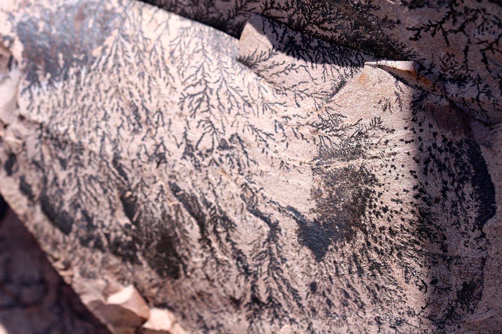
Dendrites
(c) 2015 MJ Miller |
Just over a stone's throw from Indian Mountain to the east is a rocky ridge that looks to offer more ruins. Much more difficult to ascend thanks to the lack of a trail and even more slippery loose rock, I was nearly disappointed when I reached the top only to find no apparent trace of dwellings. Disappointed, that is, until seeing the gorgeous dendrite above - a large sandstone rock covered with a delicate fern-like pattern, surrounded by the more typical lichen-covered volcanic rock.
 |
Lichens
(c) 2015 MJ MILLER |
Seeing lichens themselves is common enough in New River; they cover rocks throughout the desert, surprisingly enough for such an arid climate. I never tire of their tenacious presence.
 |
Interesting Rocks on Indian Mountain
(c) 2015 MJ Miller |
The peaks throughout New River, like those in Cave Creek, have abundant cracks and tiny grottos that were likely used to store foodstuffs or personal effects. Today, pack rats and the ever-present bees make use of them. As usual, we passed an active beehive on the climb.
 |
(c) 2015 MJ Miller
|
The Hohokam vanished completely from the Salt River Valley in the 1400's. It is likely they are the ancestors of the Papago and Pima. They burned, rather than buried, their dead in most cases; there are no burial grounds that we might clumsily stumble across. New River is filled with amazing traces of these ancient people, though - from the
manos and
metates they used to grind mesquite beans into flour to the rock art and stone dwellings.
Each time I have the privilege of sitting among the ruins, I wonder if they found the desert mountains as soul-tinglingly beautiful as I do.
 |
New River Mesa
(c) 2015 MJ Miller |
Copyright (c) 2015 by MJ Miller * All rights reserved * No part of this content, including photographs, may be used without the express permission of the author * Links to this page, however, may be freely shared and are greatly appreciated * Thank you for liking, linking, +1'ing, sharing, emailing and otherwise helping grow my readership - and most of all, thank you for stopping by!