Nestled in one of the most idyllic of locations - the Chiricahua Mountains of Cochise County - are the quiet ruins of one of the lesser-known Cavalry camps of Arizona Territory. It is a ghost fort of many names: Formally known as Camp John A. Rucker, and sometimes referred to as Fort Rucker, the site was originally known as Camp Supply (as were several other Cavalry camps) before being renamed Camp Powers. At first Camp Supply stood near a tributary of the White River, but it was relocated closer to the White River headwaters near the South Fork branch of the river. The original location was established on April 29, 1878, but by the time it was moved to the South Fork site, a double tragedy had occurred. A much-loved and respected officer, Lt. John A. Rucker, had drowned while attempting in vain to save his friend and fellow officer, Lt. Austin Henely, who'd been caught in the floodwaters of one of the desert's fierce summer monsoons on July 11, 1878. Both men had been West Point attendees, although only Henely had graduated from the academy. In honor of Rucker and the affection his men had for him, the camp was renamed in his honor, as was Rucker Canyon and the oft-dry Rucker Lake.
 |
| Lt. John A. Rucker of the 12th Infantry |
The little camp is, today, a serene gem far less known or trodden than Fort Bowie, its counterpart on the northern end of the Chiricahuas. Located near quiet campgrounds, it is accessed by taking E. Rucker Canyon Road east from US Highway 191 north of Elfrida. As you pass Devil's Canyon, you'll soon hit a fork in the road: Camp Rucker Campgrounds are off the branch to the left, and the branch to the right is marked "N. Tex Canyon Road." That's the road that actually brings you to Camp Rucker itself.

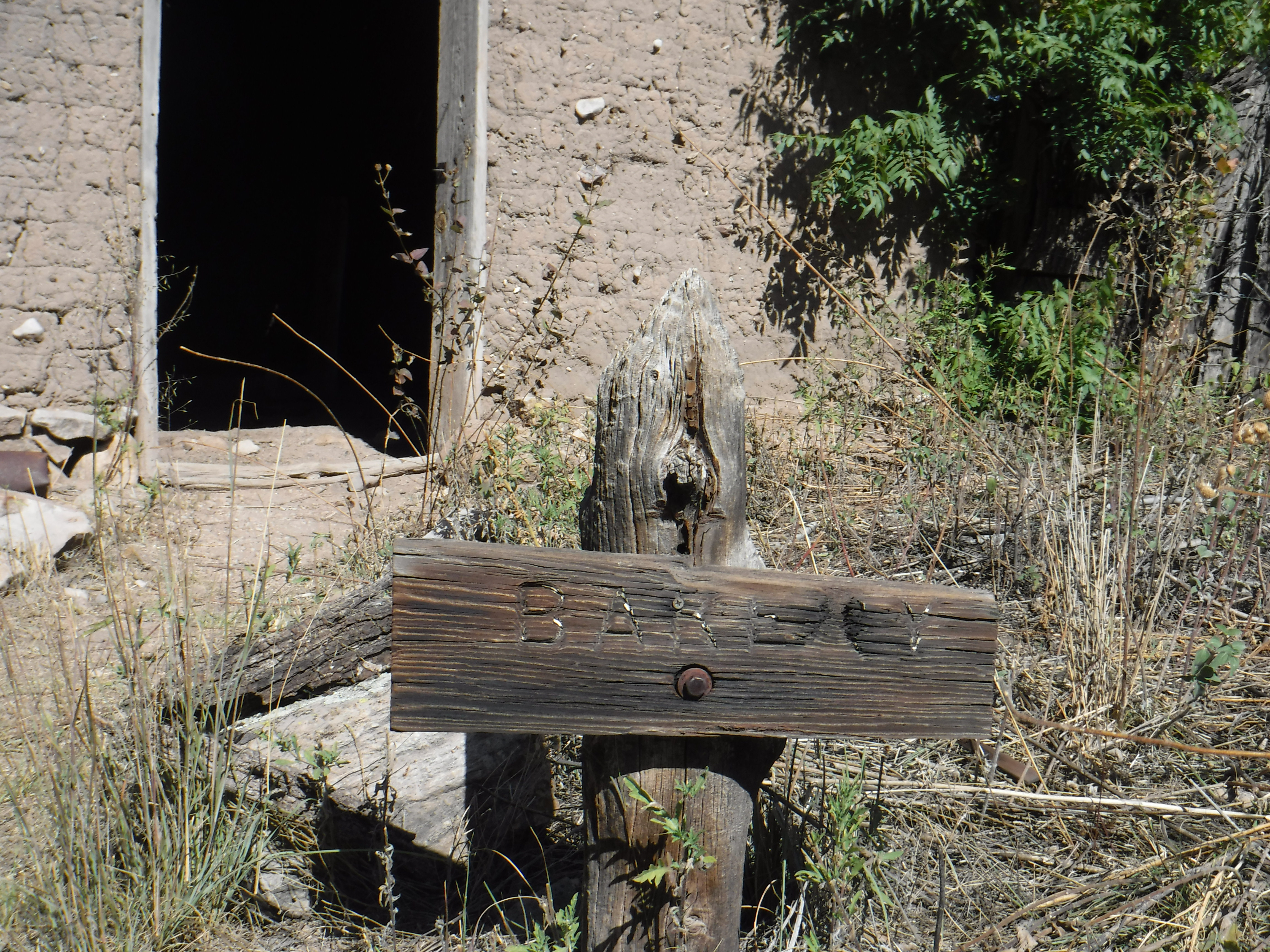
You'll likely be greeted by the local church ladies: fat Angus cows pastured adjacent to the ruins of the camp, watchful for ranchers bringing cake. Forge onward and you'll find the cavernous barn from the site's days as Old Camp Rucker Ranch, after it had been repurposed by area ranchers. (I will add a separate blog entry dealing solely with the camp's second life as a ranch, as it well deserves its own more-detailed treatment.)
 |
| Old Camp Rucker Ranch Barn |
Surrounding the barn are oak trees, pine, and the stunning backdrop of the Chiricahua cliffs and outcroppings. This time of year - late October - the colors have just begun to turn.
Beyond the barn is a surprisingly-well preserved adobe structure shaded by oak trees. The roof is new to preserve the building, but the walls are the original adobe. This was the Officers Quarters, likely built in the 1880s.
 |
| The Officers Quarters |
Unlike so many of Arizona's historic sites, the buildings at Camp Rucker are accessible: You can walk inside and admire the dappling of the sunlight through the porous rooftops, and sense the scale and feel of them. Inside the Officers Quarters is a surprisingly decorated ceiling, painted by one of the ranch wives after a marital occupation replaced the martial occupation.
 |
| Arizona Sistine: The Painted Ceilings of the One-Time Officers Quarters |
Beyond the Officers Quarters, to the northwest, stands another well-preserved adobe. Adobe, formed of mud amended with straw and other organic matter, is susceptible to the ravages of wind and rain unless coated with a protective stucco surface. The adobe buildings at Camp Rucker remain uncoated, which offers a good opportunity to see the native material - but will ultimately result in their return to the soil from whence they were created. This adobe building was the camp bakery.
 |
| Camp Rucker Bakery |
Inside the bakery is the outline of the oven, a ghost hearth of sorts, reminiscent of the large medieval hearths that both warmed homes and provided cook space.
 |
Outline of the oven at the Camp Rucker Bakery
|
The roof and ceiling of the bakery have not been replaced with steel, and still feature the original wood shake shingles; the sunlight (and, on less perfect days, the rain) comes in easily. The sunlight today dropped like so many stars on the walls and floor in a dazzling feat of natural beauty.

Yards from the bakery are the haunting remains of the original Commissary. The foundation and one corner of the walls are all that remain, a mournful footprint, since the building burned in 1921.
The final building you will find at the old camp / ranch site is the ranch house of those who followed the military - the Hampes, the Raks, and Mrs. Dana - and despite the toll the years and elements have taken, you can still imagine the cozy loveliness of it. Again, I'll go into the ranch owners separately, but include a couple of photos here in keeping with the "as it stands" theme.
Again, we're fortunate to be able to walk through these doors, just as the ranchers did, and see the view through the windows they once looked from. The ranch house was reinforced by the adobe bricks salvaged from the ruins of the Commissary, used to fortify the occupants from the cold winters in the mountains.
Although it is a weekend, we encountered only one other group of visitors during our time at Rucker today; a family on foot from the nearby campgrounds. Even the children toted rifles; it is hunting season, after all.
Never tiring of the vast vistas as you drop down from the mountains, we opted to leave via Tex Canyon Road east to US Highway 80, a sixteen-mile trek on dirt roads. Despite the warning about risking tire damage posted as we embarked, the road was easily passable - rough in spots with loose rocks, but otherwise in fine shape. I'm not sure I'd want to take it during a monsoon, but other than the knuckleheads who set camp ON the road itself, it was an easy route that brought us onto the road to either Douglas or Apache. Below are photos of selected parts of Tex Canyon Road as you enter the San Simon Valley and back onto paved roads.
If you go: Take water and weather-appropriate clothing, including a jacket, in case of emergency. There are no facilities at Camp Rucker or along the road to Hwy 80, and you will not have reliable cell phone service or Onstar. There is, however, a ranger station and campground on Rucker Canyon Road north and west of Camp Rucker historic site; to access it, backtrack along Tex Canyon Road and proceed north.
Copyright (c) 2023 Marcy J. Miller * All rights reserved * No part of this content, including photographs, may be shared without the express written permission of the author * Sharing the links to this page, however, would be greatly appreciated * Thank you for stopping by!